Ratanakiri is a province (khaet) of Cambodia located in the remote northeast. It borders the provinces of Mondulkiri to the south and Stung Treng to the west and the countries of Laos and Vietnam to the north and east, respectively. The province extends from the mountains of the Annamite Range in the north, across a hilly plateau between the Tonle San and Tonle Srepok rivers, to tropical deciduous forests in the south. In recent years, logging and mining have scarred Ratanakiri's environment, long known for its beauty.
Ratanakiri is located in Cambodia's far northeast bordered by Laos to the north, Vietnam to the east, Mondulkiri to the south, and Stung Treng to the west. This rural rugged province is a 70% ethnic minority, which are known as "Chunchiet". Ratanakiri was as recently as 2002 seriously off the beaten track but has since been "discovered" step by step.
Still, while you won't get any bragging rights for coming here, it's well worth the effort to do so, and once you get away from it's capital Banlung you won't run into too many other tourists. So Ratanakiri is still a remote province in Northeastern Cambodia worth to visit. The word "Ratanakiri" itself is a derivative of two Cambodian words, which are combined to mean "place of gems and mountains." The word comes from the Sanskrit words Ratna (gem) and giri (mountain).
It's quite dusty capital, Banlung, is located in the central highlands of the province, approximately 365 miles (586 kilometres) from Phnom Penh and reminds one of a wild western city, even if it's the wild east. Its wide red laterite roads are bordered by new, recently build houses replacing the older ones. The centre of the town features a lively marked with all the needful things.
Lomphat is a small town in the southern plains, which was once the former capital of Ratanakiri. There are a few other small towns like Ta Veng and Voen Sai. The province is getting more and more popular for thousands of tourist every year. Especially for those, who seek a close contact to originality, hidden roots of ethnic groups and abundant wildlife. Therefore the Ecotourism abounds, due to lush wildlife and remote tribal villages. Most of the inhabitants of Ratanakiri are indigenous minorities.
Ethnic Cambodians make up only 10-20% of the country's total population. Remnants of an ancient volcano exist near to Banlung in the form of a crystal-clear lake that was formed after the active volcano went dormant. There are also a few ancient lava fields that testify to the fact that the area was quite lively at one time. Beautiful waterfalls, clear rivers winding through stretches of jungle, and rolling hills that meet mountains near the Vietnamese and Lao border provide a full agenda for nature lovers. Non-structured, low-impact, custom trips to outlying villages and natural areas can be organized (strictly by yourself or with help from a guesthouse).
There is a few foreigners living in Banlung you'll definitely meet while walking in the streets you can ask for actual tour offers, prices etc (change spontaneously). You will soon realize that this area hasn't seen a lot of tourists in the past. If you will visit the hill tribe people in the further areas outside of Banlung, don't be surprised if they look appalled at you. They just haven't seen many, if any, foreigners.
Yeak Laom Volcano Lake: This beautiful place is not far from town and is great for a swim, picnic, or hike around the crater rim of the old volcano. Due to the lake's tremendous depth of 48 meters, its water is exceptionally clean and crystal clear. The lake is almost perfectly round and measures around 750 meters in diameter. It has a small informative local museum thrown in to boot. In 1995 the governor of Ratanakiri officially set aside a 5,000-hectare (12,350-acre) protected area, of which the lake is a part, and in 1996 got help from the International Development and Research Centre of Canada and the United Nations Development Program to develop an effective resource management program.
This area represents Cambodia's finest attempt at preserving a site. Full-time rangers work to ensure the area is protected. They receive regular training and have put up signs throughout the area reminding people not too littler, wash clothes or toilet in the lake. That's amazing for Cambodia. The main swimming and picnic area features a nice wood deck that's great to use for a jump into the crystal clean water. Nearby, park rangers erected a couple of examples of hill tribe construction in the form of non politically correct bride and groom homes, where the man gets the elevated home (his status in the relationship) and the woman has the one nearer to the ground.
A few hundred meters down is the Cultural and Environmental Centre, which has information about area history and displays of local hill tribe tools and handiwork. They also sell some of the handicrafts made by the hill tribes: musical instruments, beaded belts, shirts, and hats. From the centre you can take a nature trail around the entire crater rim. King Sihanouk had a chalet built on the shores of the lake and used it during the 1960s. It was destroyed in the 1970 war between the Lon Nol government and Khmer Rouge guerrillas.
You can still see the remnants of this and also-indifferent spots around the lake-trenches that held gun emplacements during the fighting. The original inhabitants of the area are the Khmer Leu hill tribe people, who have always recognized the lake as a sacred place, home to the spirits of the land, water, and forest. Here those spirits interact with humans and, according to the local legend of Yeak Laom Lake, fabulous, spiritual aquatic beings reside here.
The surrounding forests of the area are also said to be the home of spirits and therefore can't be cut. This helps to explain why the hill tribe people took so strongly to the idea of protecting the area. It's very easy to get there - just go east from the Independence Monument circle 3 km to the Hill Tribe Monument circle (two indigenous figures) and go right for about 1,5 km to the entrance gate. The local hill tribe community connected to the lake get to collect an entrance fee, giving them a source of income and revenue for protecting their resource. It?s US$1 per person and a few hundred riels for a motorcycle.
Ratanakiri is situated on the north - east plateau (approx. altitude around 200-400 metres), 636 Km from Phnom Penh. It is bordering Vietnam on the east, Laos PDR on the North, Steung Treng province on the West and Mondulkiri on the South. There are two bigger rivers crossing the province ( Sre Pork and Sresan River ). The total area of Ratanakiri is about 10,782 square kilometres.
There are 8 different hill tribes ethnic groups in Ratanakiri. Most of them live in the deeper jungle, on the hills and covered mountains in small separated villages. Usualy they make their living through traditional ways of cultivation ( shifting agriculture), hunting and collecting fruits from the forest is a must. These old cultures believe in spirits, derived from their animism beliefs. In the whole province there are 63,333 male and 64,774 female with a total of 128,107 inhabitants living. This is 11.8 inhabitans/km.
Ratanakiri Province has a climate like the other areas in the country, there are 3 seasons : - Rainy season: June - October (<27c) - Cool season: November- February (>24c) - Hot season: March- May : Temperature: from 20c -32c Ratanakiri's average temperature throughout the year is definately lower than in the other areas of Cambodia (except Mondulkiri Province).
The vast majority of the indigenous peoples living in Ratanakiri are subsistence farmers, who are planting rice, corn, pumpkins etc. Some of them grow an additional catch crop such as peanuts or cashews. There is quite a number of wealthy Cambodians and Vietnamese, who own large plantations surrounding the capital of Banlung. Most of them plant peanuts, coffee, or cashews.
Additionally, Ratanakiri boasts hundreds of square miles of lucrative rubber plantations, of which rubber is mostly exported to neighbouring Vietnam. Due to the present reconstruction of the Cambodian National Highway 19, which runs through the center of the capital of Banlung, the area's trade with Vietnam will soon rise. Anyhow Ratanakiri is so sparsely populated that the Provincial capital does not have an adequate market compete to other provinces of Cambodia. But in mineral wealth alone, Ratanakiri boasts gold, gemstones, granite and onyx. Fertile red soil, water sources, wild animals and quality hardwoods abound and the weather and scenery are perennial assets.

Beung Yeak Laom is located in Yeak Loam commune, Ban Loung district, about 5 kilometers south of Ban Loung provincial town. A lake in the middle of a mountain, it was formed many centuries ago from a ...

Virachey National Park is a national park in north-eastern Cambodia. Although partly protecting flora and fauna of international conservation priority, the park is under serious threat from illegal ...

Chư Mom Ray National Park is a national park of Vietnam in the province of Kon Tum, Central Highlands region. The national park was established according to the Decision number 103/2002/QĐ-TTg ...
Lumphat Wildlife Sanctuary is the part of Mondulkiri wildlife sanctuary, is one of Cambodia’s natural wonders. Located in the northwestern provincials of Mondulkiri and Ratanakiri ...
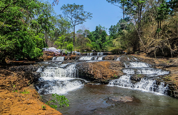
Ou'Sean Lair Waterfall is situated 26 km, South of Banlung. This Waterfall has 4 floors and the height of each floor is 4 m. The water flows throughout the year. Around the Waterfall are beautiful ...
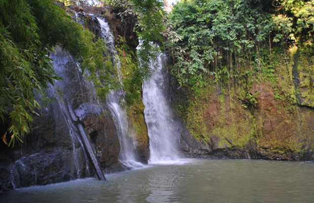
Ka Tieng waterfall is in the middle of lush forest at the Lbang I commune, Lumpart district, 7 kilometers south-west of Banlung Town. The name of Ka Tieng is originally got from Kreung hill tribe in ...

Cha Ong waterfall is in the forest in Cha Ong village, O'Chum commune, about 2 kilometers west of Ban Loung provincial town. It was given its name by the Kreung hill tribe living nearby.The waterfall ...

Locarted in Kachanh Commune, Banlung District, the kachanh Waterfall is 6 Km from the Banlung town. The waterfall is 12 meters in length, wich flow endlesslhy along the Kantoeng Stream to the Sré ...

Veal Ram Plang means the Ram Plang field and is an attractive nature spot that is part of the territories of the legendary hill tribe communities living there. It is a mesa plateau area on top of a ...
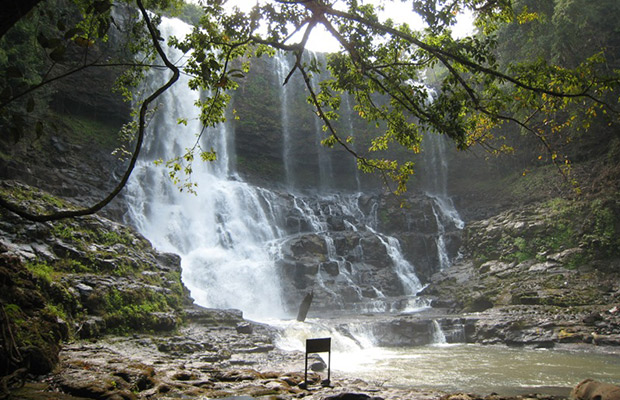
Ou'Sensranoh Waterfall is situated 9 km. south of Banlung. The height of it is 18m. and the water flows and falls all the time. The visitors can go there rest and enjoy the fresh air, or to se the ...

The Norng Kabat Forest, Ratanakiri is one of the splendid tourist attractions in Ratanakiri, which attracts tens of thousands of travelers throughout the year. The Norng Kabat Forest, Ratanakiri is ...

Phnom Eysei Patamak, which is also known as Phnom Svay,is about 2 kilometers west of Ban Loung provincial town. At the foot of the mountain is Wat Isana Rattanaram, where villagers living in Ban ...

Being the locals, we know the true value of our land. We always listen and arrange everything as your desire. Please kindly send us whatever about your trip,we will send you best offers quickly.

Guest Name: Mr. STAFFA GUILLERMO ALEJANDRO
Country: Argentina
City: ITUZAINGO - (CP: 1714)
N.of Person: 2 pax
Travel date: 1964-03-12
Booked: Full-Day Kampot-Kep including Bokor National Park Day Tour
Tour Style: Day Trip Tours
Duration: Full Day