Cha Ong waterfall is in the forest in Cha Ong village, O'Chum commune, about 2 kilometers west of Ban Loung provincial town. It was given its name by the Kreung hill tribe living nearby.The waterfall gets its water from Phnom Eysei Patamak or Phnom Svay near Ban Loung provincial ...
Cha Ong Waterfall locates at the middle of the forest in Cha Ong village, Ou Chum District in approximate two-kilometer distance from the Ban Lung town ty the National Road No. 19 ( Ban Lung-Steung Treng), then turning right by a trail about six-kilometer. We call the waterfall “Cha Ong” because we follow the ethnic minority of Kreung at Cha Ong village closed to the waterfall. The source of this waterfall is coming from the mountain named Ey Sey Park Ta Mak” or called “Phnom Svay” closed to the Ban Lung town.
The situation from about is a small canal which continuously flows through the broken rocks, then to the stream in 25-kilometer height. For viewing the waterfall, we should go down to the stream below where we have seen a big rocky cave with the plain roof. At the bottom of the stream, there are many big rocks use as the seats for viewing the great and interesting water falling down from the mountaintop.
Cha Ong waterfall is in the forest in Cha Ong village, O'Chum commune, about 2 kilometers west of Ban Loung provincial town. It was given its name by the Kreung hill tribe living nearby.The waterfall gets its water from Phnom Eysei Patamak or Phnom Svay near Ban Loung provincial town. From its upper level, the water flows from a small canal before dropping 25 meters to a lower level. A mountain slop leads visitors to the bottom of the waterfall, where they can sit inside a cave and enjoy the view.
The waterfall gets its water from Phnom Eysei Patamak or Phnom Svay near Ban Loung provincial town from its upper level, the water flows from a small canal before dropping 25 meters to a lower level. A mountain slop leads visitors to the bottom of the waterfall, where they can sit inside a cave and enjoy the view.Ka Chanh waterfall is located in Ka Chanh commune, Ban Loung district, about 6 kilometers southeast of Ban Loung provincial town. The waterfall is 12 meters high and is fed year round by the OKan Teung canal.
From the waterfall the water flows into Sre Pork River in Lum Phat district. The waterfall was given its name by the Kreung ethnic minority in Ka Chanh village.There are a number of scenic rubber plantations along the canal leading to the waterfall. The base of the waterfall, which is a lovely place for picnic, can be reached by climbing down are also available.We call the waterfall 'Cha Ong' because we follow the ethnic minority of Kreung at Cha Ong village closed to the waterfall.
The source of this waterfall is from the mountain named 'Ey sey Pak Ta Mak' or called 'Phnom Svay' closed to the Ban Lung town. The situation from above is a small canal which continuously flows through the broken rocks, then to the stream below in 25-kilometer height. To view the waterfall, we should go down to the stream below where we have seen a big rocky cave with plain roof. At the bottom of the stream, there are many big rocks used as the seats for viewing the great and interesting water falling down from the mountaintop.
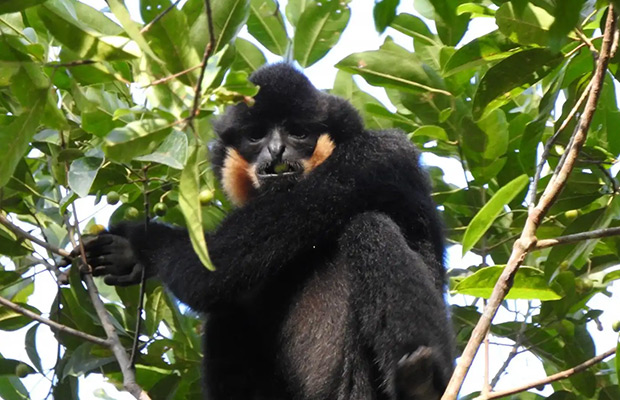
This adventure not only includes the incredible newly discovered ‘northern yellow-cheeked gibbons’ but also the lost temple of Beng Mealea, the beautiful Yaek Lom volcanic crater lake and a local ...

Join us on this four day trip through Virachey National Park. You will be sleeping in a Hammock in the Jungle (and maybe woken up by Gibbons), building a Bamboo Raft for a trip on the Olalai River, ...
Veun Sai -Siem Pang National Park (VSSPNP) is located in northeastern Cambodia. It covers an area of over 50,000 hectares with a large area of vast evergreen forests. VSSPNP riches with many ...
An elephant trek through the forest in Ratanakiri in Cambodia is a great experience, nice and different way of exploring the area with its forests and people. Tour start at 8:30am-return to hotel in ...

We will depart from Banlung, the capital of Rattanakiri province and cross the Sesan River by ferry an hour north of town, where we will be met by our indigenous guides who will show you the ...

We will reach the VNP border where we take a break for lunch with a Kavet indigenous family who live on the outskirts of the village there in a beautiful spot beside a clear river surrounded by hills ...

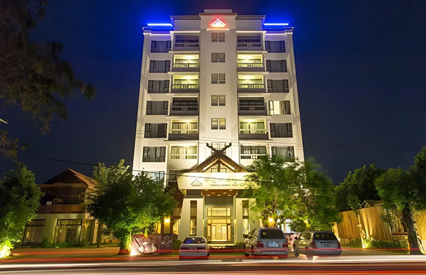
1-167 Street 29, Krong Ban Lung, Ratanakiri Province, Cambodia
Best Seller!
Located in Ban Lung, Yeak Loam Hotel is within a 5-minute drive of Ban Lung Market and Eisan Ratanaram Pagoda. This hotel is 2.8 mi (4.5 km) from Yeak Laom Lake and 3.8 mi (6.1 km) from Boeng Yeak Lom.
Take advantage of recreation opportunities such as an outdoor pool or take in the view from a rooftop terrace and a garden. Additional features at this hotel include complimentary wireless internet access and concierge services.
Grab a bite at one of the hotel's 2 restaurants, or stay in and take advantage of the room service (during limited hours). Wrap up your day with a drink at the bar/lounge.
Featured amenities include a business center, dry cleaning/laundry services, and a 24-hour front desk. Free self parking is available onsite.
Make yourself at home in one of the 70 air-conditioned rooms featuring minibars and LED televisions. Complimentary wireless internet access keeps you connected, and cable programming is available for your entertainment. Bathrooms have complimentary toiletries and hair dryers. Conveniences include phones, as well as safes and desks.
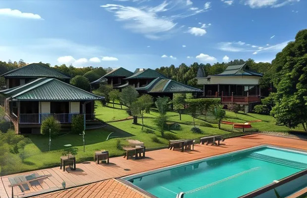
Loun Village, Yeak Laom, Krong Banlung 3 km on road from Yeak Laom Lake to Ou'Sean Lair, Yeak Laom, Ratanakiri Province, Cambodia
Best Location!
Great care is taken to ensure guests experience comfort through top-notch services and amenities.Remain linked during your visit by utilizing the complimentary internet access available. Prior to your check-in date, you can arrange airport transportation services, guaranteeing a seamless and efficient experience for both arrival and departure. Services offered by taxi, car hire and shuttle at the resort ensure effortless exploration of Banlung.
The resort offers complimentary parking for guests who arrive with their own mode of transport. Effortlessly plan your daily activities and travel requirements with concierge service, express check-in or check-out, luggage storage and safety deposit boxes provided by the front desk services.Securing passes to the city's top attractions is simple with the resort's ticket service and tours.
During your stay at this fantastic resort, experience comfort and warmth from the delightful on-site fireplace on those chilly days and nights.Repeatedly enjoy your best-loved attire with the aid of the laundry service available at Ratanakiri Paradise Hotel & Restaurant. During leisurely days and evenings, in-room amenities such as room service and daily housekeeping enable you to maximize your stay in the room. The resort is completely smoke-free. In limited designated zones, smoking is exclusively permitted. Each morning at Ratanakiri Paradise Hotel & Restaurant, a scrumptious, homemade breakfast kick-starts the day.
Begin your holiday mornings right with your essential cup of coffee, offered daily at the cafe on-site.During your visit, indulge in a range of delightful culinary choices at resort to enhance your experience.Experience a fantastic evening effortlessly! Relish an entertaining night without venturing beyond the confines of the bar. Do you possess exceptional culinary skills? Prepare your meals personally within the resort at its BBQ facilities. Indulge in the numerous pursuits available at Ratanakiri Paradise Hotel & Restaurant. During your stay, the resort provides direct access to a beach, ensuring you remain near the sea throughout your visit.Treat and spoil yourself by stopping at massage, hot tub, spa and sauna for a memorable experience.Begin your holiday perfectly by taking a plunge into the swimming pool.At the resort, enjoy a laid-back beverage experience by the poolside bar, sipping on a soothing cocktail.
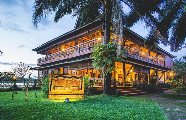
N°222, St 422, Phum Tes Anlong Sanghat Beung Kansaign, Banlung, Ratanakiri Province, Cambodia.
Best for Traveller!
Located in Ban Lung, Terres Rouges Lodge is in a national park, within a 5-minute drive of Ban Lung Market and Eisan Ratanaram Pagoda. This hotel is 3.4 mi (5.6 km) from Yeak Laom Lake and 4.4 mi (7.1 km) from Boeng Yeak Lom.
Enjoy recreational amenities such as an outdoor pool and bicycles to rent. Additional features at this hotel include complimentary wireless internet access, concierge services, and barbecue grills.
Satisfy your appetite for lunch or dinner at the hotel's restaurant, or stay in and take advantage of the room service (during limited hours). Relax with your favorite drink at the bar/lounge or the poolside bar.
Featured amenities include express check-in, express check-out, and dry cleaning/laundry services. Guests may use a roundtrip airport shuttle for a surcharge, and free valet parking is available onsite.
Make yourself at home in one of the 26 air-conditioned rooms featuring refrigerators and LCD televisions. Complimentary wireless internet access is available to keep you connected. Private bathrooms with bathtubs or showers feature complimentary toiletries and bathrobes. Conveniences include safes and desks, and housekeeping is provided daily.

Being the locals, we know the true value of our land. We always listen and arrange everything as your desire. Please kindly send us whatever about your trip,we will send you best offers quickly.

Guest Name: Mr. STAFFA GUILLERMO ALEJANDRO
Country: Argentina
City: ITUZAINGO - (CP: 1714)
N.of Person: 2 pax
Travel date: 1964-03-12
Booked: Full-Day Kampot-Kep including Bokor National Park Day Tour
Tour Style: Day Trip Tours
Duration: Full Day